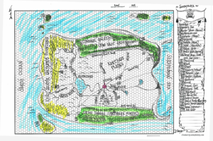
Karthus Plains
The Karthus Plains is a vast grasslands dotted with settlements and cities and towns, connected by a web of roads and hollow ways, some so ancient they were constructed by the Apadians themselves. The Karthus would take many days to traverse north to south, and some weeks east to west, longer if travel by foot without steed or mount. Radiating outward in each direction from the capital, Vesuva, are towns and smaller settlements, typically agrarian centers closer to Vesuva, and trading posts further away. Bounding the north of the Karthus is the Tinwael Galéth, The Vast Greenwood, home of wood elves and fae creatures; an ancient forest with its own thought and memory reaching back eons. The Greenwood stretches all the way to the northern coasts, into the arctic archipelagos dotted with folk somewhat untouched by time. The southern reaches of the Karthus are bounded by the Urdai Sinwal, The Greybark Forest. This southern forest is teeming with the high elves and forest gnomes, halflings, and other non-human creatures in some numbers. While warmer than the Greenwood, the Greybark affords a dense canopy, enabling even underground creatures to feel comfortable traveling through it at night. The eastern bounds of the Karthus spill into the Sarapadian Sea, with rocky cliffs on the northern shores giving way to sandy beaches in the south. The backbone of the Karthus lies in the west, where the steep rocky crags of the Khâl Dakhîr, the Skyrend Mountains, weaves a high wandering swath from north to south, dropping off steeply into the Dârivi Ocean on the west, while curling and flattening into the Greenwood in the north and the Greybark in the south.
The Karthus is divided by a web of rivers, streams, lakes, reservoirs, fens, and canals. The Ossîgo River collects the glacial runoff from the Skyrend as it merges into the Greenwood with dozens of feeds from small streams and rivers. The Ossîgo sweeps south sharply; then as it approaches Vesuva from the west, it is waylaid into a large lake, the Silvermere, which is joined by the Hâzek River from the southwest, the confluence of streams from the southern half of the central range of the Skyrend. As the Silvermere bulges eastward toward Vesuva, the Yana River rushes in a wide ribbon chasing itself through wide bends until bisecting Vesuva proper. A wide set of canals crisscross the northeastern reaches of the Silvermere and connect shortcuts and irrigation systems to and north of the Yana. To the east of Vesuva, the Yana winds lazily to the Sarapadian Sea, with some reservoirs along the way which were the old strip mines used to acquire the limestone used to build Vesuva. More canals bleed of to the northeast of Vesuva feeding more fields. Small rivulets split off from the Yana south of Vesuva, creating the Coalfens which stretch for more than a day south of Vesuva.
